Page Not Found
Page not found. Your pixels are in another canvas.

A list of all the posts and pages found on the site. For you robots out there is an XML version available for digesting as well.
Page not found. Your pixels are in another canvas.
About me
Since taking a job as a data scientist three months ago, I’ve spoken with multiple political science PhD students who are interested in potentially making the same transition. This post synthesizes what I’ve said in those conversations with what I’ve learned in my first three months on the job, and I hope it will be helpful to anyone in the same position I was six months ago.
When I was applying to graduate school and asking for letters of recommendation from my undergrad professors, one of them told me to give academia three years, and that if I hadn’t found a permanent position by then, to find another career. It’s been three years, and next week I start a new job as a data scientist. I read a fair bit of quit lit in my first couple years of grad school and always told myself that if I went that same route, I would never pen any of my own…
As part of the publication process for my recent article on how states preempt separatist conflict, I needed to submit replication materials to the journal. I took my graduate quantitative methods sequence with the late Tom Carsey, so I’ve long been a proponent replicability efforts in social science. I also had an hourly job in grad school replicating quantitative results for multiple political science journals, so I’m very familiar with best practices for replication. Unfortunately, in the four years since I wrote the first line of code for this project, somewhere in between defending my dissertation and starting a new job (ok, fine, almost immediately after writing that first line of code), I got a little lazy.
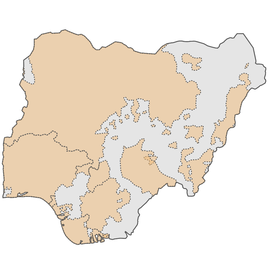
I recently needed to create a choropleth of a few different countries for a project on targeting of UN peacekeepers by non-state armed actors I’m working on. A choropleth is a type of thematic map where data are aggregated up from smaller areas (or discrete points) to larger ones and then visualized using different colors to represent different numeric values.
Like many people, I’ve been spending more time outdoors during this pandemic. While this means daily walks in my neighborhood, it also means getting out into the wilderness and sleeping in a tent when I can. Although outdoor recreation is one of the safer ways to entertain yourself these days, it’s not without its own concerns. The difficulty of safely getting to trailheads means that while I’m backpacking more than usual, it’s still not as often as I’d like.
Trias Aditya, Febri Iswanto, Ade Wirawan, Dany Laksono. 2011. "Teaching Programming Skills in Methods Courses is an Opportunity, not a Burden." 2nd International Workshop on 3D Cadastres. http://resolver.tudelft.nl/uuid:15802be4-3ed3-4cc7-971a-5178a89907da
Djurdjani, Dany Laksono. 2016. "Open source stack for Structure from Motion 3D reconstruction: A geometric overview." 2016 6th International Annual Engineering Seminar (InAES) pp. 196-201, doi: 10.1109/INAES.2016.7821933.
Trias Aditya, Dany Laksono. 2017. "LOD 1: 3D CityModel for Implementing SmartCity Concept." 2017 International Conference on Information Technology p 136–141, doi:10.1145/3176653.3176734
Atriyon Julzarika, Dany Laksono, Luki Subehi, Esthi Kurnia Dewi, K Kayat, Hanhan A Sofiyuddin, Media Fitri Isma Nugraha. 2018. "Comprehensive integration system of saltwater environment on Rote Island using a multidisciplinary approach." Journal of Degraded and Mining Lands Management J. Degrade. Min. Land Manage., pp. 1553-1567. doi:10.15243/jdmlm.2018.061.1553
Trias Aditya, Dany Laksono, Heri Sutanta, Nur Izzahudin, Febrian Susanta. 2018. "A Usability Evaluation of a 3d Map Display for Pedestrian Navigation." The International Archives of the Photogrammetry, Remote Sensing and Spatial Information Sciences XLII-4/W10, 3–10, doi:10.5194/isprs-archives-XLII-4-W10-3-2018
Dany Laksono. 2018. "Testing spatial data deliverance in SQL and NoSQL database using NodeJS fullstack web app." 2018 4th International Conference on Science and Technology (ICST) pp. 1-5, doi: 10.1109/ICSTC.2018.8528705.
Dany Laksono, Trias Aditya. 2019. "Utilizing a game engine for interactive 3D topographic data visualization." ISPRS International Journal of Geo-Information 8(8), 361. doi:10.3390/ijgi8080361
Trias Aditya, I Ari Sucaya, Fajar Adi Nugroho, Han Han Lukman Syahid, Dany Laksono. 2019. "Developing an LADM-compliant Mobile Data Collector for Accelerating Participatory Cadastral Mapping and Registration Activities." 8th Land Administration Domain Model Workshop. LADM2019
Dany Laksono, Trias Aditya. 2019. "Crowdsourced hotspot validation and data visualisation for location-based haze mitigation." Journal of Location Based Services. p 239-269. doi:10.1080/17489725.2019.1619851
Trias Aditya, Dany Laksono, Febrian F Susanta, I Istarno, D Diyono, Didik Ariyanto. 2020. "Visualization of 3D survey data for strata titles." ISPRS International Journal of Geo-Information ISPRS Int. J. Geo-Inf. 2020, 9(5), 310; https://doi.org/10.3390/ijgi9050310
Trias Aditya, Dany P. Laksono, Dedi Atunggal, Febrian F. Susanta, Nurrohmat Widjadjanti, Mohammad B. Setiawan, Nurhidayat Agam and Tri Wibisono. 2021. "3D Modelling, Validation and Visualization of 3D Parcels in First Registration for 3D Cadastre - Indonesia Case." 7th International FIG Workshop on 3D Cadastres p 247-261
Subehi, L., Julzarika, A., Dianto, A., Laksono, D. P., & Sofiyuddin, H. A. (2022). NATURAL COMPOUNDS AQUATIC PLANT BIODIVERSITY OF LAKE LEDULU, ROTE DEAD SEA AREA-INDONESIA FOR RECOMMENDATIONS OF CONSERVATION. International Journal of Conservation Science, 13(4), 1377-1392.
Sutanta, H., Chintya, N., Laksono, D., Atunggal, D., & Diyono, D. (2023). Developing Address Model and Geocoding Framework for Urban Area in Indonesia.
Susanta, F. F., Muryamto, R., & Laksono, D. P. (2024, January). The 15-minute city of mass public transportation in Yogyakarta: case of Trans Jogja bus. In Eighth Geoinformation Science Symposium 2023: Geoinformation Science for Sustainable Planet (Vol. 12977, pp. 25-32). SPIE.